Prepared for Naval Research Reviews - 4 May 1999
Adaptive Sampling for Ocean Forecasting
Allan R. Robinson and Scott M. Glenn
Abstract
Real-time regional forecasting of the coastal ocean is a challenging task, complicated by the oceans episodic nature, the lack of extensive observations, and the combined influence of internal processes and interactions with boundaries on the evolution of the forecast fields. Adaptive sampling is an evolving methodology for the efficient sampling of ocean phenomena in support of real-time nowcasting and forcasting activities. Ocean Observation and Prediction Systems (OOPS) provide a framework for acquiring, processing and assimiliating data in a dynamical forecast model which can then generate forecasts of 3-d fields and error esimates that can be used to optimize adaptive sampling schemes for specific goals. Modern OOPS applications with adaptive sampling are presented for the Harvard Ocean Prediction System (HOPS) and the Rutgers University Long-term Ecosystem Observatory (LEO-15). Interdisciplinary models, new assimilation methodologies, new sensors, autonomous platforms, automated system responses will further improve adaptive sampling capabilities in the next decade.
I. Real Time Regional Forecasting
The ocean is intermittent, eventful, and episodic. It is an essentially turbulent fluid whose circulation is characterized by a myriad of dynamical processes occurring over a vast range of nonlinearly interactive scales in space and time. Ocean forecasting is essential for effective and efficient operations on and within the sea, and such forecasting has been initiated, e.g. for military operations, coastal zone management and scientific research. Observations are used to initialize dynamical forecast models, and further observations are continually assimilated into the models as the forecasts advance in time. Such observations are generally difficult, costly and sparse. If a region of the ocean were to be sampled uniformly over a predetermined space-time grid, adequate to resolve scales of interest, only a small subset of those observations would have significant impact on the accuracy of the forecasts. The impact subset is related to intermittent energetic synoptic dynamical events. For most of the energetic variability in the ocean, the location and timing of such events is irregular and not a priori known. However, a usefully accurate forecast targets such events and forms the basis for the design of a sampling scheme tailored to the ocean state to be observed. Such adaptive sampling of the observations of greatest impact is efficient and can drastically reduce the observational requirements, i.e. by one or two orders of magnitude.
The ocean evolves in time, both as a direct response to external surface and body forces, and also via internal dynamical processes. The former include, for instance, tidal forces, winds and surface fluxes of heat and fresh water. Where air-sea interactions are important, an accurate meteorological forecast is needed for the ocean forecast. Oceanic internal instabilities and resonances, which include meanders of currents, frontogenesis, eddying and wave propagation, are generally analogous to atmospheric weather phenomena and are called the internal weather of the sea. The spatial scales of important internal ocean weather phenomena are short and require ocean forecasts to be carried out regionally rather than globally. The regional forecast problem then has additional forces appearing as fluxes through horizontal boundaries, representing both larger scales of direct forcing, remote internal dynamical events and land-sea interactions in the littoral zone. The development of a regional forecast system and capability depends both upon the scales and processes of interest and the scales and processes that are dominant in the region. The design of sampling schemes is constrained both by generic and special regional issues. The forecast region or region of influence is often necessarily larger than the region of operational interest. Additional challenging issues in sampling design include efficient real time forecast protocols and the acquisition of data adequate for both updating and verification purposes.
Ocean science and marine technology today are increasingly interdisciplinary. Fields of forecast interest include physical, acoustical, optical, biological, chemical and sedimentological state variables. Velocities, temperatures, sound speed, scattering, irradiances, plankton concentrations, chlorophyll and suspended particles are some examples. Interdisciplinary compatibility requirements constrain multi-disciplinary sampling schemes. Some variables are of direct interest while others are useful for interdisciplinary field estimation, e.g. acoustic travel times for the estimation of temperature gradients. Thus, as the scope of ocean prediction expands, the challenging adaptive sampling problem that emerges is the design of sampling schemes for the acquisition of multi-scale compatible interdisciplinary data sets based upon real time observations and realistic forecasts. The specific purpose of the forecast which will utilize the data guides both the design of the sampling and the choice of a forecast skill metric. The adaptive sampling problem defined in the last two sentences is the topic of this paper.
II. Characterization of the Coastal Ocean
The short term evolution (1-5 days) of the mesoscale ocean circulation at times is controlled by non linear internal processes associated with the density-driven flows, especially in deeper water. As water depths decrease, forcing from the boundaries (surface, bottom, offshore, inshore, and lateral) and turbulent mixing is often of similar importance or greater (ex. Keen and Glenn, 1998).
Atmospheric momentum and buoyancy fluxes produce daily to seasonal variations in the upper mixed layer and the seasonal thermocline. Coastal upwelling/downwelling is caused by the Ekman transport, which in the deepwater limit is associated with alongshore winds and Coriolis forces, but in the often neglected shallow water limit is associated with cross-shore winds.
Bottom interactions on the continental shelf are complicated by the effects of surface waves that feel the bottom, and by a moveable sediment bed. Both the non linear wave-current interaction in the wave boundary layer, and the increased roughness due to ripple formation, act to increase the bottom stress felt by the lower-frequency currents, while suspended sediment induced stratification acts to decrease the bottom stress.
At the outer boundary, interactions with deepwater eddies and boundary currents can produce cross-shelf exchanges or along-shelf pressure gradients that force the outer-shelf. Along the coastal boundary, estuaries are a source of freshwater, producing buoyant plumes and alongshore surface jets on the inner-shelf. Entering through lateral cross-shelf boundaries, coastal-trapped, externally generated waves can propagate along the coast through a region of interest.
The observation and prediction of coastal circulation is further complicated by the presence of a continuum of wave motions of similar magnitude or greater than the boundary or internally forced currents. Surface waves, internal waves and solitons, barotopic and baroclinic tides, and inertial waves may occur simultaneously, and each may interact with the mean flow by modifying the turbulence, especially near the thermocline where the largest shears are often encountered.
We have chosen to emphasize the features, variabilities and complexities of the physical coastal ocean (Robinson and Brink, 1999) and will only briefly mention the equally, if not more important, multi- and inter-disciplinary processes. Coastal conditions support vigorous marine ecosystems and are of utmost importance for living marine resources. Primary production occurs in phytoplankton blooms in response to seasonal stratification, wind-driven and topographic upwelling, tidal-mixing and nutrient advection events. The dynamics of interactive, multi-scale physical-biological variabilities (phytoplankton and zooplankton patchiness) is currently a research topic of critical importance for both understanding and managing coastal seas. The forward and inverse acoustic propagation problems across the shelfbreak and in shallow waters involve critical bottom interactions and require careful treatment of attenuation, scattering and reverberation.
III. Adaptive Sampling Concept
The concept of experimental and observational sampling being well matched to the phenomena of interest is deeply rooted in modern scientific methodology. The success of Newtonian physics was based upon the rigorous requirement of subjecting dynamical hypotheses to quantitative testing by experimental facts. An iterative process has evolved, with feedbacks between theory and experimentation, which involves both agreements with pre-existing data and predictions of new measurements. Practical material and human resource constraints demand efficient measurements, an issue of particular concern in oceanography. Efficient sampling requires a priori knowledge of scales that may be simple (e.g. periodic) or complex (e.g. multi-scales arising from nonlinear interactions).
If scales are known for intermittent episodic phenomena, adequate uniform sampling, as referred to in section I, is possible but not very efficient. Coarser sampling misses entirely or at best aliases the phenomena (MODE Group, 1978, Section 1). Finer sampling is redundant. Optimal sampling requires a priori estimates of the state of the ocean during the sampling interval. To carry out such observations adaptively requires flexible and efficient platforms well matched to the phenomena. Consider a scenario in which two (or more) platforms are available together with a real time data telemetering capability. One platform provides continuous good coverage from a fixed position or predetermined track (saturated data, e.g. from a coastal CODAR or satellite altimeter). The second platform, generally costly to operate in the forecast region, provides targeted data (sparse data, e.g. from a ship, aircraft or AUV) on events identified but incompletely sampled in the real time saturated data stream. Additionally, if a usefully reliable forecast model exists, present and future events can be identified from model nowcasts and forecasts instead of from a saturated data stream, but more powerfully in conjunction with such a data stream.
The adaptive sampling strategy will attempt to minimize a selected error measure and the estimate of the error must take into account data type, sampling and assimilation scheme (see Section 6). Contemporary scientific methodology is tripartite, involving theory, experimentation and realistic simulations now possible because of rapidly increasing computational resources. Observational System Simulation Experiments (OSSEs) now play an essential role in quantitatively assessing adaptive sampling strategies (Robinson et al., 1998).
Historically oceanographers have always adaptively sampled with respect to known scale information. Early examples include biological sampling (or harvesting) of estuarine ecosystems at appropriate phases of the tidal cycle and the design of physical time series with regard to Nyquist frequency considerations. The existence of dominant mesoscale variability in the ocean which was discovered in the 1960s, and described and quantified in the 1970s (Robinson, 1983), led naturally to the initiation of ocean forecasting during the 1980s (Mooers et al., 1986). During that decade the present authors independently carried out adaptive sampling research, for example in conjunction with the first real time shipboard forecast of the California Current evolution (Robinson et al., 1986) and with the provision of strong ring-current advisories to dynamically positioned deep water oil drilling vessels (Glenn et al., 1990). Together we devised weekly event-related P3 AXBT flights in support of research/operational forecasting of Gulf Stream meanders and rings for the US Navy from November 1986 to January 1989 (Glenn and Robinson, 1995). During the 1990s the opportunities and requirements for multi-scale, interdisciplinary ocean forecasting have sharpened, the term adaptive sampling for ocean observational networks was articulated (Curtin et al., 1993), and the concept of Ocean Observing and Predictions Systems has firmly emerged.
IV. Ocean Observing and Prediction Systems (OOPS)
Advanced ocean observing and prediction systems (OOPS) now exist for field estimation. An OOPS consists of an observational network, data analysis and assimilation schemes and a suite of interdisciplinary dynamical models. Generally multiple interactive scales require compatible observational and modeling nests, and efficiency requires a well-chosen mix of sensors and platforms for a particular problem. The concept of advanced ocean prediction systems is represented schematically (Figure 1a) by the LOOPS (Littoral Ocean Observing and Prediction System) architecture (Patrikalakis et al, 1999). The LOOPS system is modular, based on a distributed information concept, providing sharable, scalable, flexible and efficient workflow and management for interdisciplinary data collection, assimilation and forecasting. The Harvard Ocean Prediction System (HOPS), described below and illustrated in Figure 1b, is at the heart of LOOPS. An OOPS can be generic and portable (e.g. HOPS (Robinson, 1999)), or designed and implemented for specific regions or processes (e.g. LEO-15 (Glenn et al., 1998)).
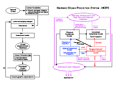
FIGURE 1: a) architecture of advanced high-level ocean observing and prediction system; b) architecture of Harvard Ocean Prediction System (HOPS)
Data assimilation, which melds observations with dynamics, provides the only feasible basis for obtaining accurate synoptic mesoscale realizations over the space-time scales and domains of interest. Data assimilation dynamically adjusts and interpolates data inserted into models (Robinson et al., 1998). Data assimilation methods being used or adapted today for ocean science have their roots in engineering and meteorology and are generally based on estimation theory, control theory or inverse techniques. Error models are an intrinsic element of data assimilation schemes and errors are propagated together with forecast fields. Data assimilation or inverse methods allow for the estimation of parameters such as eddy diffusivities and rate parameters and the inference of processes from the balance of terms in dynamical equations. The control of predictability error (see Section 6) via data assimilation initiated by meteorologists is interesting for the interdisciplinary ocean forecasting problem in the light of the nonlinearities inherent in coupled biological and physical models.
Modern ocean observation networks use multiple platforms including remote (satellites, aircraft and shore-based), stationary (surface and subsurface), moveable (ships and AUVs), and drifting (surface or vertically mobile). The Rutgers LEO-15 system is illustrated in Figure 2 and described below. Advances in satellite, line-of-site radio, and underwater acoustic communications enable real-time data transmission, which prompts development of automated processing and visualization algorithms. Instantaneous product dissemination via the World Wide Web promotes the formation of distributed networks, with different groups responsible for individual systems. The proliferation of distributed observation networks allows one to envision a patchwork of well-sampled coastal ocean regions in which the role of sparse adaptive sampling will change relative to the role of saturated measurements. In the well-sampled ocean, adaptive sampling can begin to focus on observations that improve or otherwise compensate for imperfect model physics, such as unparameterized turbulent mixing mechanisms, as the dominant source of forecast error.
Interdisciplinary ocean science involves a hierarchy of complex coupled physical-acoustical-biogeochemical-ecosystem dynamical models. Physical models are generally primitive equation (PE) models, but small scale coastal phenomena can be represented via non-hydrostatic models. Boundary layers (top and bottom) and turbulence are modeled through process parameterization, second order closure, or large eddy simulation. Basic biological mechanisms are generally known (although not as well known as physics) but much remains to be learned about their manifestations in real ocean processes and their appropriate representation in dynamical models. Mechanisms such as nutrient uptake, grazing, mortality, etc. are highly non linear in nature. There are an almost unlimited number of potential state variables (species, life-stages, trophic levels, nutrients, etc.) and the choice of aggregations appropriate for particular problems (critical state variables) is a demanding aspect of modeling. Higher trophic levels of biology require behavior modeling. Acoustic propagation has a variety of approximate dynamics, depending on frequency and complicated by circulation, bottom and surface interactions, biological interactions, etc.
Operational high-resolution (10-30 km) regional atmospheric models may adequately resolve most atmospheric processes, but coastal ocean fronts can occur at the kilometer scale. To determine if the smaller scale ocean features feedback on the atmosphere and influence their own evolution, an even higher resolution atmospheric model can be nested within the operational models, or a planetary boundary layer model can be coupled to each grid point of the ocean model and forced at the top with the operational resolution model. The first approach drastically increases runtime, while the second approach assumes the ocean influence is primarily local.
V. Research in progress and operational examples
HOPS (see Figure 1b) is a flexible, portable and generic system for inter-disciplinary nowcasting, forecasting and simulations. HOPS can rapidly be deployed to any region of the world ocean, including the coastal and deep oceans and across the shelfbreak with open, partially open or closed boundaries. Physical, and some acoustical, real time and at sea forecasts have been carried out for more than fifteen years at numerous sites (Robinson, 1999) and coupled at sea biological forecasts were initiated in 1997. The present system is applicable from 10m to several thousand meters and the heart of the system for most applications is a primitive equation physical dynamical model. Work is in progress to extend the system to estuaries and to include a non-hydrostatic option. Multiple sigma vertical coordinates have been calibrated for accurate modeling of steep topography. Multiple two-way nests are an existing option for the horizontal grids. The modularity of HOPS facilitates the selection of a subset of modules to form an efficient configuration for specific applications and also facilitates the addition of new or substitute modules. Data assimilation methods used by HOPS include a robust (suboptimal) optimal interpolation (OI) scheme and a quasi-optimal scheme, Error Subspace Statistical Estimation (ESSE). The ESSE method determines the nonlinear evolution of the oceanic state and its uncertainties by minimizing the most energetic errors under the constraints of the dynamical and measurement models and their errors. Measurement models relate state variables to sensor data. Real time efficiency is achieved by reducing the error covariance to its dominant eigendecomposition.
HOPS utilizes a variety of observational networks in its applications. Satellite sea surface temperature, height and color are routinely utilized as available. HOPS, on shipboard, has recently forecast physics and acoustics from data gathered by the RV Endeavor during the ONR Shelfbreak PRIMER experiment, and physics and biology from data gathered by the RRS Discovery in the Northeast Atlantic during the Plankton Patchiness Studies by Ship and Satellite experiment. Interactive adaptive sampling with the MIT Odyssey AUVs was initiated in shallow water during the 1996 ONR Haro Straits tidal fronts experiment (Nadis, 1997). In recent NATO Rapid Response exercises, the observational networks included the SACLANTCEN NRV Alliance, additional NATO military and research vessels and P3 aircraft and ARGOS floats. A multi-scale, interdisciplinary observational network is illustrated in the opening figure for the recent LOOPS Massachusetts Bay Sea Trial 1998.
2. LEO-15 Observation and Modeling System
The Rutgers University Long-term Ecosystem Observatory (LEO-15) (Grassle et al., 1998) is an instrumented natural littoral laboratory that spans the 3 m to 30 m water depths offshore Tuckerton, New Jersey with a 30 km x 30 km well-sampled research space (Figure 2). This inner shelf region has "often been ignored in the past because of the very difficult operating conditions and the complex dynamics, where the water is effectively filled with turbulent boundary layers" (Brink, 1997). Real-time surface data from remote sensing platforms, combined with real-time subsurface data from remotely-operated and autonomous nodes, provide 3-D nowcasts to guide adaptive sampling with up to five coastal research vessels and a fleet of AUVs (long-range gliders, medium-range REMUS survey vehicles, and short-range REMUS turbulence vehicles) (Glenn et al., 1998).
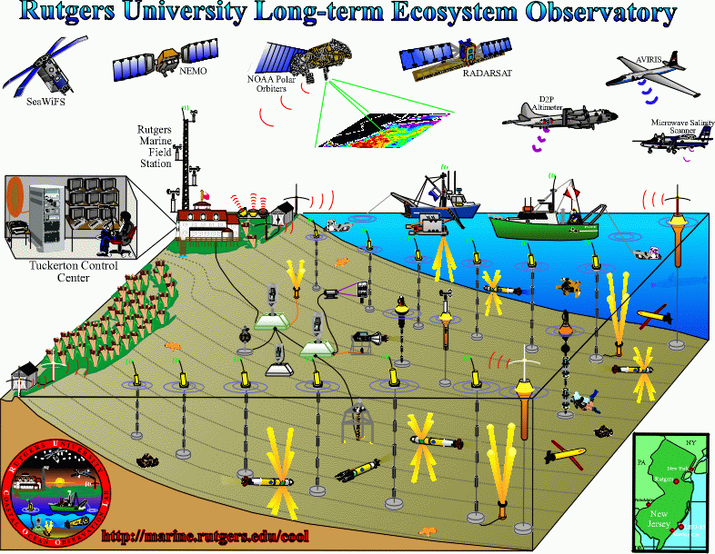
Figure 2: The LEO-15 observation network operated offshore of Tuckerton, New Jersey during the annual Coastal Predictive Skill Experiment.
Coastal forecasts for adaptive sampling are generated using Rutgers' Regional Ocean Modeling System (ROMS), a primitive equation model with a free sea surface, curvilinear horizontal grid, a stretched (S-coordinate) vertical grid, and open boundary conditions allowing two-way forcing between small and large scales. Turbulence closure is achieved using the KPP scheme (Large et al., 1994) modified to include overlapping surface and bottom boundary layers and wave-current interactions (Styles and Glenn, 1999). Data assimilation options include nudging, optimal interpolation and a reduced-state Kalman filter. Atmospheric forcing options include operational Navy products that drive a planetary boundary layer model, or direct coupling to a high-resolution Regional Atmospheric Modeling System (RAMS).
3. HOPS examples
Figures 3 and 4 illustrate the use of HOPS during recent NATO Rapid Environmental Assessment (Pouliquen et al., 1997) Rapid Response exercises in 1996 and 1998. A real time nowcast for 18 Sept. 1996 is shown in Figure 3a. This nowcast is the combination of a 3-day forecast with AXBT data whose expected analysis error is shown in Figure 3b. The data-forecast melding was performed using ESSE assimilation. The sampling patterns of data collection for ships and aircraft (Sellschopp and Robinson, 1997) were subjectively adapted in real time, combining shipboard predictions with operational needs in order to sample areas of influence for the region of interest. Figure 4a is a real time nowcast for 21 March 1998, melding the field forecast with all the past data up to that day, via data assimilation. Figure 4b is the forecasted error standard deviation, from the ESSE assimilation scheme, of the temperature at 100m. The error field and the associated dominant eigenvectors of error covariance forecasts were utilized to design adaptive patterns of AXBT flights for the region, in accord with practical, operational and meteorological constraints.
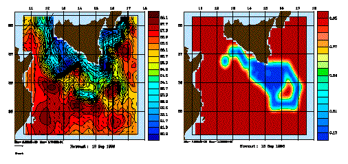
Figure 3: Surface temperature map for 18 Sept. 1996 in the Strait of Sicily region overlaid with surface velocity vectors (a). The Atlantic Ionian Stream is a free jet meandering from west to east with a strong thermal front between 25-26° C.; b) Normalized expected error (0-1) of the surface temperature mapped from the new observations
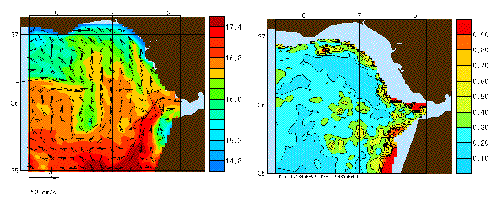
Figure 4: Melded estimate of temperature in the Gulf of Cadiz with velocity vectors after data assimilation for 21 March 1998 (a) and forecast error estimate (b) .
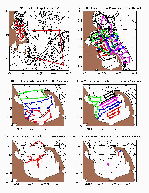
Figure 5 and the cover figure illustrate the interdisciplinary forecast experiment that occurred for more than two months in Massachusetts Bay in late summer and early fall of 1998. This demonstration of concept real time sea trial field experiment was performed in collaboration with the LOOPS (NOPP), Advanced Fisheries Management and Information Service (AFMIS, NASA, Rothschild et al., 1998) and Autonomous Ocean Sampling Network (AOSN, ONR, Curtin et al., 1993) programs. The scientific focus was phytoplankton and zooplankton patchiness, in particular, the spatial variability of zooplankton and its relationship to physical and phytoplankton variabilities. Simultaneous synoptic physical and biological data sets in 4 dimensions were obtained over a range of scales. This data was assimilated into HOPS using OI and ESSE. Real time forecasts of fields and error covariance eigendecompositions were provided. These forecasts were utilized for adaptive sampling (cover figure) and for the calibration of the model parameters. Several dynamical interactions among the circulation, productivity and ecosystem systems were inferred.
Figure 5a shows the chlorophyll-a concentration at 10m, overlaid with horizontal velocity vectors at the same depth. Figure 5b is a cross-section of chlorophyll-a concentration along the entrance of Massachusetts Bay, from Race Point to Cape Ann. The multi-scale patchiness of the chlorophyll field is clearly visible. Higher concentrations occur at the northeast of Cape Ann and near Boston Harbor because of the continued supply of nutrients, over Stellwagen Bank due to tidal mixing, and at several locations along the coastline, because of local wind driven upwelling and episodic wind mixing.
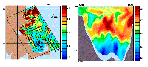
Figure 5: Example chlorophyll-a concentration at 10m with horizontal velocity vectors for MBST-98 (a) and vertical section of chlorophyll-a concentration from Race Point to Cape Ann (b).
Statistical error models previously developed for other ocean regions (Lermusiaux,1999) were calibrated and verified for use in Massachusetts Bay. The initial error subspace was set to the a priori dominant, synoptic mesoscale variability in the Bay, which is related to the dominant subspace of the so-called GFD singular vectors (Palmer et al, 1998). Adaptive sampling methodologies were carried out in real-time for two months, as illustrated by the cover figure. The multi-scale sampling strategies were based on: (1) ocean field forecasts assimilating all prior data (regions of most active or interesting dynamics) and (2) forecasts of error variances and of dominant eigendecompositions of error covariances, using ESSE. The optimal strategies were subject to weather and operational constraints. The figure shows the multiplicity of scales of such strategies. The R/V Able-J (Panel a) was used to sample the Bay scales and the external oceanic forcings (note the adapted zigzag in the Gulf of Maine and over Georges Bank). The R/V Oceanus (Panel b) sampled the mesoscales, outside of Cape Cod Bay, and in the open boundary forcing regions. The R/V Lucky Lady sampled the mesoscale (Panel c) and submesoscales (Panel d), mainly in Cape Cod Bay. The Odyssey AUV's (Panel e) sampled the submesoscales in Cape Cod Bay. Finally, the Remus AUV's (Panel f) sampled the turbulent scales in Cape Cod Bay. All of the sampling patterns of these platforms and sensors were designed and made available in real-time, assimilating yesterday's data today for tomorrow's forecast and sampling. These accomplishments have resulted in a combined and compatible physical and biological multi-scale data set applicable to interactive process studies and data assimilation, adaptive sampling, and predictive skill OSSEs.
4. Coastal Predictive Skill Experiments at LEO-15
A series of Coastal Predictive Skill Experiments (CPSE) were begun at LEO-15 starting in 1998. The summer 1998 CPSE focused on improving nowcast skill for adaptive sampling using spatially extensive real-time data. The summer 1999 CPSE will focus on improving model forecast skill for adaptive sampling via coupling to a regional atmospheric model, improved turbulent closure, and real-time updates of the offshore boundary conditions. Future CPSEs will emphasize the coupling between physical and bio-optical components.
The phenomenological focus of the CPSEs is the development of recurrent coastal upwelling centers and their effect on phytoplankton and suspended sediment distributions. Figure 6 illustrates the initial development of an upwelling center in which the ocean model has assimilated the more extensive radial currents from each of two on-shore CODAR HF-Radars (Kohut et al., 1999). The initial development is characterized by the cyclonic curvature in the northward flowing upwelling jet and the surfacing of the cold upwelled water nearshore.
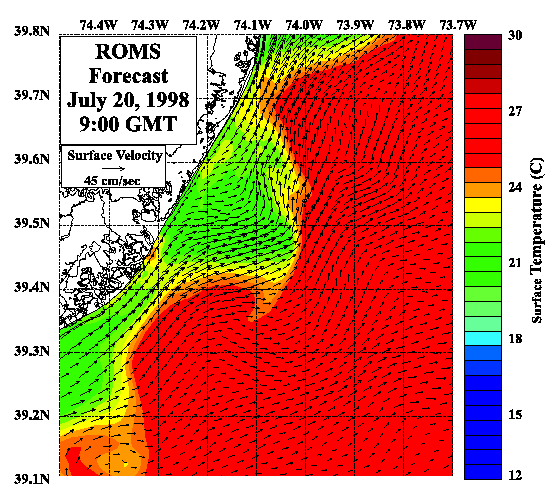
Figure 6: Sea surface temperature and surface current forecast of the initial formation of an upwelling center generated by the Regional Ocean Modeling System (ROMS) forced with operational Navy atmospheric forecasts while assimilating surface current radial velocity components from the individual CODAR sites.
Three days later, the surface current and temperature nowcast indicated that the upwelling jet was now meandering around a cyclonic eddy embedded within the cold upwelling center. This data-based nowcast, a model forecast for continued upwelling, and model sensitivity studies indicating a dependence on turbulent closure in the vicinity of the eddy, were used to define three cross-shelf transects for sampling over a two day period. A ship-towed SWATH ADCP and an undulating CTD/Fluorometer (Creed et al., 1998) were sent to patrol the transect just north of the eddy center, and a REMUS survey vehicle was sent to patrol the transect just south. The REMUS turbulence vehicle was sent directly into the eddy center to observe the changing turbulence characteristics as the vehicle drove out of the eddy and crossed the upwelling front.
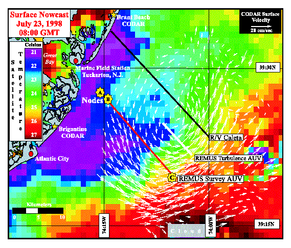
Figure 7: Sea surface temperature and surface current nowcast of a fully-developed upwelling center derived by detiding and low-pass filtering the combined CODAR vector velocities. Lines indicate the locations of the three cross-shelf repeat transects chosen for subsurface shipboard and AUV sampling.
The alongshore current component (Figure 8, color contours) acquired by the REMUS survey vehicles not only indicates that the northward-flowing upwelling jet on the offshore side is confined to the region above the thermocline, it also reveals a southward-flowing, subsurface jet on the nearshore side. The systems towed along the northern transect uncovered a similar velocity structure, with the highest phytoplankton concentrations of the season discovered within the subsurface jet. The subsurface adaptive sampling data suggest that phytoplankton concentration increases within the upwelling center may be dominated by advection from the north.
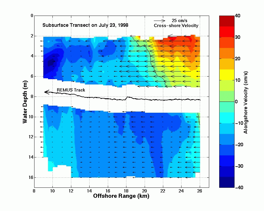
Figure 8: Alongshore (color contours) and cross-shore (arrows) velocity components derived from the upward and downward looking ADCPs on the REMUS Survey AUV as it ran shoreward along the southern transect at a depth near 8 m.
Eddy viscosities derived from the REMUS turbulence vehicle were found to be two orders of magnitude greater on the inshore side of the upwelling front compared to the offshore side. Idealized tests of the modified KPP closure (Figure 9) indicate that maximum eddy viscosities are expected just shoreward of the upwelling front. Standard turbulent closure schemes produce the exact opposite, a minimum in the eddy viscosity just shoreward of the front. Coupled biological model sensitivity studies indicate that the biological response can be even more sensitive to vertical mixing parameterizations than the physical model.
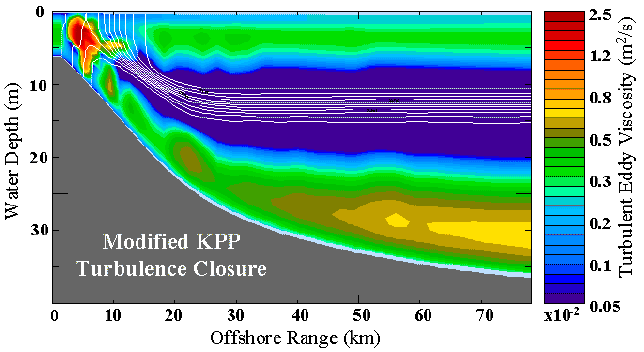
Figure 9: Idealized cross-shelf transect of turbulent eddy viscosity (color contours) and density (white lines) generated by the modified KPP closure, with the largest viscosities found shoreward of the density front
VI. Adaptive sampling research and the control of errors
In modern ocean adaptive sampling, a goal characterizes the ideal future sampling among the possible choices, in an adaptive accord with the constraints and available forecasts that have assimilated all of the past data. This goal can be achieved either subjectively, with forecast information being combined with the a priori experience to intuitively choose the future sampling, or quantitatively, where forecast capabilities serve as input to a mathematical sampling criterion whose real-time, continued, optimization predicts the adapted sampling. The parameters of the adaptive sampling procedure are therefore the available forecasts, new data acquired during the forecast, the constraints and the goal, i.e. the properties to be optimized and the metrics used to measure these properties.
Today, the forecast capabilities include the future evolution of the ocean fields, of their variabilities and of their uncertainty or error statistics (Lermusiaux, 1999). There are constraints from practical considerations (platforms and sensors available, airport locations, ship speeds, AUV range, weather conditions, etc), dynamical motives (search for precursor of the primary phenomenon, dynamical model verifications), and cost penalties (batteries, fuel, human costs). There are scientific and technical constraints for the measurement model to generate the actual state variables to be assimilated. For example, adaptive sampling of coastal currents may be severely constrained by the sampling requirements of a measurement model that separates the frequencies of interest (the model velocity state variables for assimilation) from the spectrum of frequencies observed (surface and internal waves, tides, inertial waves, etc.). Finally, several goals or criterion are also possible, in varied representations (e.g. physical vs. Fourier space). For example, the optimum can be the sampling that minimizes the forecast of the field error variances over the global domain and scales of interest, subject to the cost penalties and practical constraints. Other types of optima are the sampling that ideally determines specific properties of the future dynamics (e.g., potential vorticity), irrespective of the past data and other constraints, or, the sampling that allows the best skill evaluation. In assimilation studies, the goal should be in accord with the data assimilation criteria. For example, if the assimilation aims at minimizing the field error with a variance metric (i.e. trace of the error covariance), the adaptive sampling criteria should aim at determining the future sampling that also minimizes the trace of the error covariance (see Section 5.3).
An important component involves the theoretical and numerical optimization procedure, to be carried out in real-time. For linear systems, the optimization can be implemented beforehand, independently of the future data values, only using the dynamical and measurement models and their statistical uncertainties. However, for nonlinear models, the data values matter, and forecast OSSEs need to be carried out during the optimization process. To do so, the results of the last decades in optimal control and estimation theory (Robinson et al., 1998) are ready to be utilized and further developed by the interdisciplinary oceanographer in the quest for the most useful data.
VII. Research Directions and Future Prospects
During the 1990's interdisciplinary ocean science has been rapidly evolving and now comprises an increasingly important and substantial component of marine science. This has been based upon progress in the understanding of realistic ocean dynamical processes in the sub-disciplines, and the identification of new realistic coupled and interdisciplinary dynamical processes is presently a research frontier. More and more attention is being focused on the coastal ocean and its deep sea and terrestrial interactions. The requisite four dimensional field estimates necessary for continued progress in multi-scale interdisciplinary ocean science and technology can only be provided by advanced littoral ocean observing and prediction systems with adaptive sampling. Ocean science, ocean engineering and marine technology are symbiotic among themselves and are deeply rooted in the fundamental and engineering sciences. Complex ocean systems research today is interdisciplinary with important aspects of computer, information and communication sciences.
Coastal ocean adaptive sampling is in its infancy and methodological advances in the next several years will be related to advances in the observing and prediction systems components, the overall system concept and system integration, as well as dedicated theoretical research on objective, automated sampling. Platform advances will include ocean gliders, improved AUV capabilities and unmanned aircraft. Fleets of robotic autonomous platforms will operate with sampling patterns altered in consideration of data pooled and analyzed aboard command platforms. New sensors are under design, construction and test for hyperspectral ocean optics, microwave salinity and coastal altimetry measurements. Interdisciplinary multi-scale ocean models will be validated for a variety of (interactive) processes; calibration and sensitivity procedures will be established. Process feedbacks for coupled regional atmospheric and oceanic models will be better understood and some coupled systems will be undergoing verification from both regional and generic points of view. Research issues involved in developing the methodology of quasi-optimal assimilation of interdisciplinary multi-scale multi-fields in real time should be clarified. The advanced OOPS concept is of a flexible, modular, scaleable, distributed system capable of efficiently managing large pre-existing and novel databases. Fully integrated OSSEs, which include both scientific process and engineering operational constraints, will be underway. The suitability of adaptive sampling goals for various purposes will be studied and better understood and, hopefully, associated quantitative metrics will not be strongly dependent upon the methodology of their implementation. With recent progress towards the implementation of real-time optimal control and optimization algorithms, computed optimal samplings will give the assimilation scheme the observations it needs most, hence ideally improve the ocean field estimate. Such theoretical adaptive sampling studies need to be carried out for both covert and overt operations.
Experience of recent past decades indicates that the first decade of the twenty first century should result in the maturing and evolution of both interdisciplinary ocean science and technology, and the ocean observing and prediction system concept. Powerful new field estimation and regional predictive capabilities can be expected to transform overall operational capabilities for naval rapid environmental assessment and societal environmental crisis response and, supported by rapidly expanding observational infrastructure and a strong national coastal program, to provide the basis for effective and efficient management of multi-use coastal zones.
Acknowledgements
We are grateful to Dr. Pierre F.J. Lermusiaux, Michael Crowley and Wayne G. Leslie for essential contributions to the preparation of this manuscript, and thank Prof. Henrik Schmidt, MIT, for interesting remarks. We are both supported by grants from the Office of Naval Research and the National Ocean partnership Program.
Biographies
Allan R. Robinson is the Gordon McKay Professor of Geophysical Fluid Dynamics
at Harvard University. He holds BA (mcl), MA and PhD degrees in physics from Harvard and honorary doctorates from the Universities of Liege and Massachusetts. His research includes dynamics of rotating and stratified fluids and ocean currents, and the influence of physical processes on biological dynamics in the ocean. He is recognized as a pioneer and leading expert in ocean prediction and data assimilation. He has served on numerous national and international advisory committees and has chaired many programs for international cooperative science, including mesoscale dynamics, ocean prediction, and ecosystem dynamics. He has authored and edited nearly 200 articles and books and is currently editor-in-chief of THE SEA and Dynamics of Atmospheres and Oceans.
Scott M. Glenn received his Sc.D. in Ocean Engineering from the WHOI/MIT Joint Program in 1983. He currently is a Professor of Marine and Coastal Sciences at Rutgers University, where he co-directs the Coastal Ocean Observation Lab. His recent research activities at LEO-15 include the development of distributed multi-platform ocean observation networks for real-time nowcasting, improved algorithms for numerical ocean models to increase coastal forecast skill, and new adaptive sampling techniques using towed and autonomous systems for interdisciplinary applications.
References
Brink, K.H., 1997. Observational coastal oceanography, Advances and Primary Research Opportunities in Physical Oceanography Studies (APROPOS) Workshop, NSF-sponsored workshop on the Future of Physical Oceanography, 15-17 December, 1997.
http://www.joss.ucar.edu/joss_psg/project/oce_workshop/apropos/presentations/brink.html
Creed, E.L., S.M. Glenn and R. Chant, 1998. Adaptive Sampling Experiment at LEO-15.
OCC '98 Proceedings, Sea Technology, November, pp. 576-579.
Curtin, T.B., J.G. Bellingham, J. Catipovic and D. Webb, 1993. Autonomous ocean sampling networks, Oceanography, 6(3), pp. 86-94.
Glenn, S.M., G.Z. Forristall, P. Cornillon and G. Milkowski, 1990. Observations of Gulf Stream Ring 83-E and Their Interpretation Using Feature Models. Journal of Geophysical Research, 95, 13,043--13,063.
Glenn, S.M., and A.R. Robinson, 1995. Verification of an Operational Gulf Stream Forecasting Model. Qualitative Skill Assessment for Coastal Ocean Models,
Coastal and Estuarine Studies, 47, American Geophysical Union, D. Lynch and A. Davies, eds., 469-499.
Glenn, S.M., D.B. Haidvogel, O.M.E. Schofield, J.F. Grassle, C.J. von Alt, E.R. Levine and D.C. Webb, 1998. Coastal Predictive Skill Experiments at the LEO-15 National Littoral Laboratory. Sea Technology, April, pp. 63-69.
Grassle, J.F., S.M. Glenn and C. von Alt, 1998. Ocean Observing Systems for Marine Habitats. OCC '98 Proceedings, Sea Technology, November, pp. 567-570.
Keen, T.R. and S.M. Glenn, 1998. Factors influencing hindcast skill for modeling shallow water currents during Hurricane Andrew, J. Atmos. Ocean. Tech., 15, pp. 221-236.
Kohut, J.T., S.M. Glenn and D.E. Barrick, 1999. SeaSonde is Integral to Coastal Flow Model Development, Hydro International, April, pp. 32-35.
Large, W.G., J.C. McWilliams, and S.C. Doney, 1994: Oceanic vertical mixing: A review and model with a nonlocal boundary layer parameterization, Reviews of Geophysics, 32, 363-403.
Lermusiaux, P.F.J., 1999. Data assimilation via error subspace statistical estimation, Part II: Mid-Atlantic Bight shelfbreak front simulations and ESSE validation, Monthly Weather Review, in press.
MODE Group, 1978. The Mid-Ocean Dynamics Experiment, Deep-Sea Research, 25, pp. 859-910.
Mooers, C.N.K., A.R. Robinson and J.D. Thompson, 1986. Ocean Prediction Workshop 1986: A status and prospectus report on the scientific basis and the NavyÆs needs. In: Proc. Ocean Prediction Workshop, Inst. Naval Oceanogr., NSTL, MS.
Nadis, S., 1997. `Real-timeÆ oceanography adapts to sea changes, Science, 275, 28 March 1997, pp. 1881-1882.
Patrikalakis, N.M., P.J. Fortier, Y.E. Ioannidis, C.N. Nikolaou, A.R. Robinson, J.R. Rossignac and A. Vinacua, 1999. Distribution Information and Computation in Scientific and Engineering Environments. D-Lib Magazine, 5(4), http://www.dlib.org/dlib/april99/04abrams.html
Pouliquen, E., A.D. Kirwan, Jr., and R.T. Pearson, eds., 1997. Rapid Environmental Assessment, Proceedings Int. Conf. Rapid Environmental Assessment, Lerici, Italy, Mar. 10-14, 1997.
Robinson, A.R., ed., 1983. Eddies in Marine Science, Springer, Berlin, 609 pp.
Robinson, A.R., 1999. Forecasting and simulating coastal ocean processes and variabilities with the Harvard Ocean Prediction System, in Coastal Ocean prediction, (C.N.K. Mooers, ed.), AGU Coastal and Estuarine Studies Series, American Geophysical Union, pp. 77-100.
Robinson, A.R. and K.H. Brink, eds., 1999. THE SEA: The Global Coastal Ocean, Volume 11: Regional Studies and Syntheses, John Wiley and Sons, NY.
Robinson, A.R., J.A. Carton, N. Pinardi and C.N.K. Mooers, 1986. Dynamical forecasting and dynamical interpolation: an experiment in the California Current, Journal of Physical Oceanography, 16: 1561-1579.
Robinson, A.R., P.F.J. Lermusiaux and N.Q. Sloan, 1998. Data assimilation, in THE SEA: The Global Coastal Ocean, Volume 10: Processes and Methods (K.H. Brink and A.R. Robinson, eds.), pp. 541-594.
Rothschild, B., A. Robinson, A. Gangopadhyay, S. Besiktepe, J. Bisagni, A. Cabeza, D. Cai, P. Fortier, P. Haley, H.S. Kim, E. King, L. Lannerole, P. Lermusiaux, W. Leslie, C. Lozano and M. Miller, 1998. Management Information System and the Precautionary Approach, Presented at the ICES Symposium on Confronting Uncertainty in the Evaluation and Implementation of Fisheries-Management Systems, 16-19 Nov. 1998, Cape Town, South Africa.
Sellschopp, J. and A.R. Robinson, 1997. Describing and forecasting ocean conditions during Operation Rapid Response, Rapid Environmental Assessment (E. Pouliquen, A.D. Kirwan, Jr., and R.T. Pearson, eds.), Proceedings Int. Conf. Rapid Environmental Assessment, Lerici, Italy, Mar. 10-14, 1997, pp. 35-42.
Styles, R., and S.M. Glenn, 1999. Modeling Stratified Wave-Current Bottom Boundary Layer Model for the Continental Shelf. Journal of Geophysical Research, submitted.