by
Sukru Besiktepe, Allan R. Robinson,
Dimitri Kroujiline, Jeffrey Dusenberry
15 October 1998 - DRAFT
This report presents the initial analyses and scientific results of the biogeochemical simulations in the Mass. Bay and Cape Cod Bay regions based upon observations during September-October 1998 and estimates of the subtidal circulation carried out in real time during the period of September 2 through October 2.
Overview of the biogeochemical characteristics of the Mass Bay/Cape Cod Bay during Summer
Review of the Mass Bay and Cape Cod Bay biogeochemical structure is done using MWRA summer data (Figure 2). During August-September, in general, the mixed layer extends to a depth of 2m to 10m, with a thermocline to 20m. The chlorophyll maximum (generally peaking about 2-2.5 mg/l) is generally about 15-25m, just below the mixed layer. Depth of the chlorophyll maxima is controlled by light and nutrient availability. The nitracline is typically just below the chlorophyll maximum, and peaks in ammonium concentration are observed somewhat deeper ( 20-30 m). Both nutrients are depleted within the mixed layer and the biological production in the photic zone is nutrient limited. Hence the production is controlled by the physical processes bringing nutrients to the photic zone.
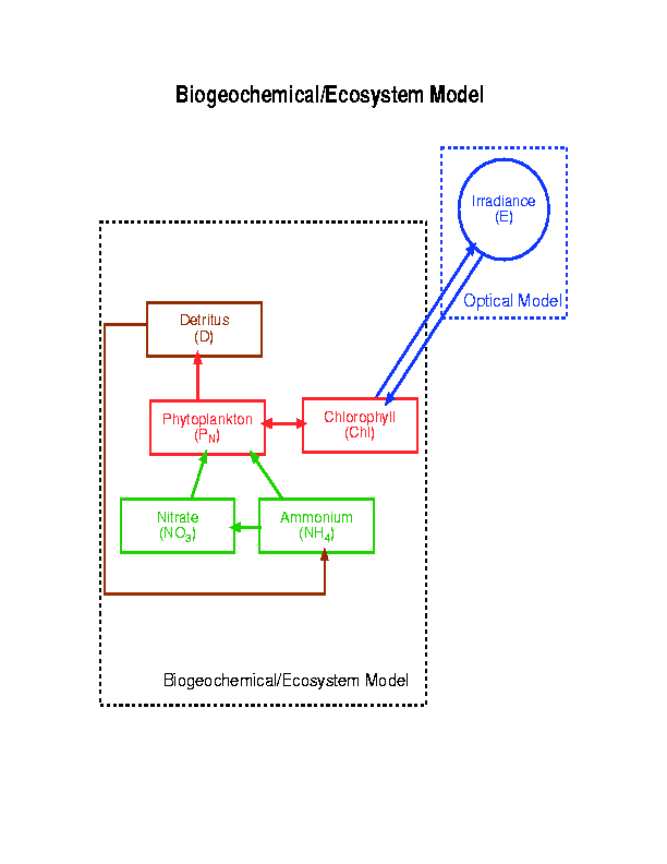
The bio-chemical model coupled to physical model includes phyto-plankton P, zoo-plankton Z, detritus D, nitrate NO3, ammonium NH4, and chlorophyll Chl. The model equations and conceptual design of the food-web are given in Table 1 and Figure 1, respectively. Description of the model parameters and their values used in the Mass Bay model simulations are given in Table 2.
Biological data collected during Mass Bay cruises consist of;
Lucky Lady and Oceanus chlorophyll fluorescence measurements are in the relative units and needs to be converted to mg/l using direct chlorophyll measurements. Data quality control procedures will be exercised using the chlorophyl data, just received today. Nitrate and ammonium data will be received within next month.
Zooplankton size class measurements were done using TAPS during Oct 4 and 5. This data converted to mm3/m3 by Van Holliday. Conversion to the model units (mmolN/l) were done by using results of the Wiebe et. al. 1975.
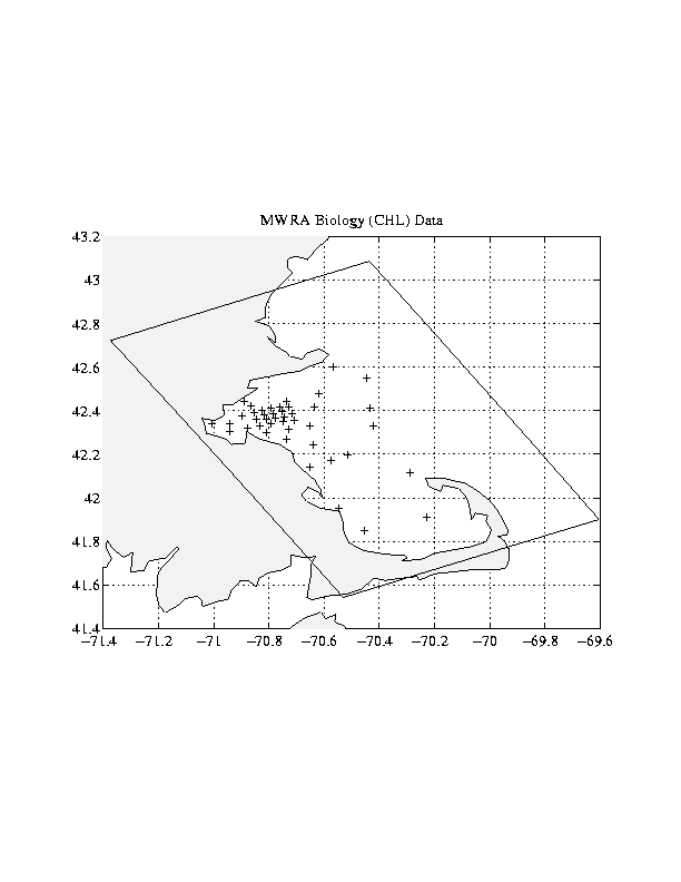
The model initialized using temperature and salinity fields from the Lucky Lady survey (August 17) and biological variables initialized using Massachusetts Water Resources Authority (MWRA) data collected during an August 1995 far field cruise. The model domain and MWRA sampling stations are given in Figure 2. The model is forced with FNOC twice-daily meteorological fields. Shortwave radiation is interpolated to hourly values assuming half-sine curve between sun rise and sun set giving maximum at mid day. Physical data collected during real-time experiment were assimilated in the model.
Biological fields are not necessarily consistent with each other, with the model parameters due to the sampling resolution, errors in the measurements and uncertainty of the parameters. Hence we adjusted biological field before coupling physical and biological model. We run the 3-d model for 10 days without advection for this purpose. Only vertical diffusion was allowed and the model forced with light.
Physical model were run for 5 days to adjust vertical velocities. Then we performed coupled physical biological model simulations.
There are four main physical processes affecting the biological productivity;
Two sources of nutrient into the photic zone in the Mass Bay has been identified up to now as:
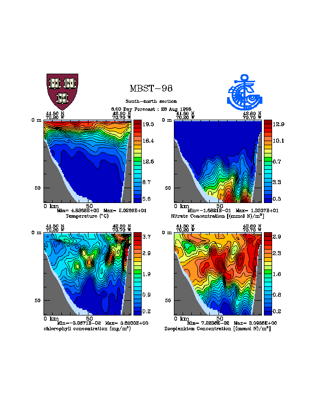
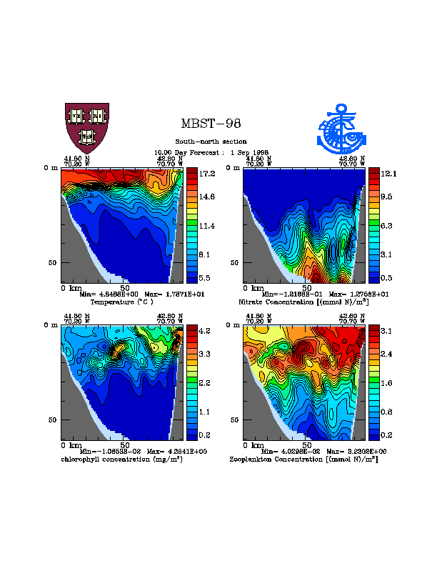
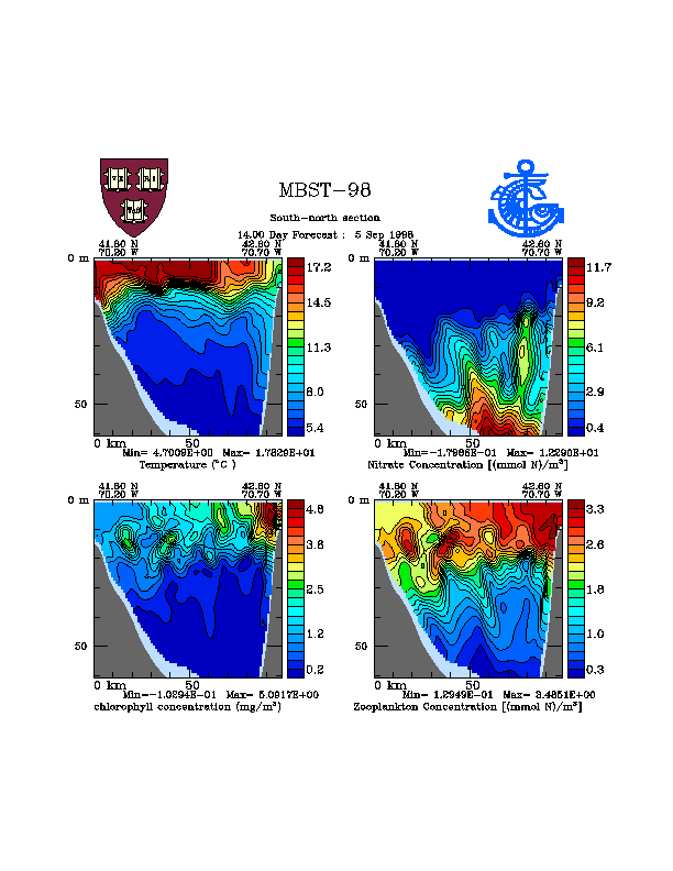
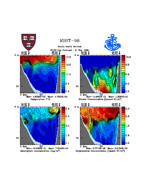
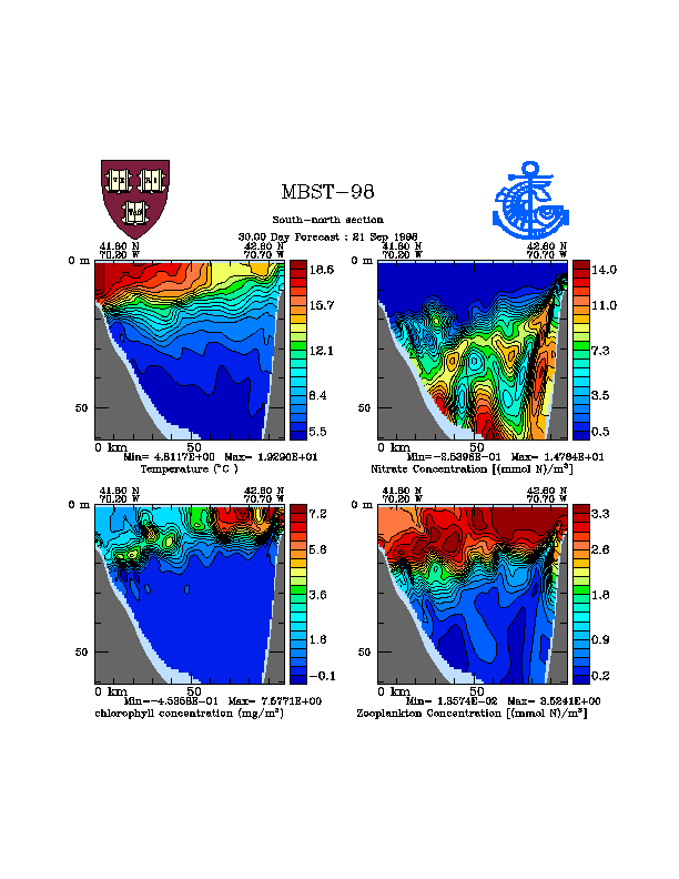
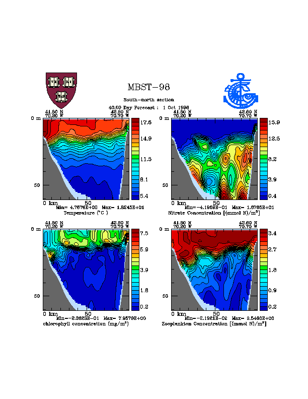
Vertical structure of the biological variables during the Mass Bay experiment are given in Figure 4. Ammonium and nitrate are depleted all together within the mixed layer during the summer months. This implies unavailability of nitrate uptake to support the primary production inside the mixed layer. Diffusion of the nutrients below the base of mixed layer and the availability of the light at these depths support the primary production and then chlorophyll-a distribution displays sub-surface maxima (about 2-2.5 mg/l) at the base of the mixed layer which is a common feature for the summer months in the area.
The nitrate concentrations begin to increase gradually after September, as the cooling starts to initiate some mixing within the water column. Strong winds during summer-autumn transient may also bring nutrient rich deep waters to surface leading to occasional phytoplankton blooms.
Waters underlying the euphotic zone, the ammonium concentrations increase as the consequences of typical regenerative and respiratory processes. Ammonia data indicates that the concentrations in the productive surface layers (euphotic zone) are around 0.1-0.3 mmol m-3 and reaches to 2-3 mmol m-3 below the euphotic zone.
At the end of August (Figure 4a) the mixed layer is at 10m, nitrate concentration below the mixed layer is about 10 mmol/m3. Chlorophyll-a maxima is 3 mg/l and the depth of the chlorophyll maxima displays inclination from north to south. Its at 10m at the northern boundary of the Mass Bay and deepens to 30m at the southern part. Upwelling at the northern boundary is obvious from temperature and biological variables. Chlorophyll-a and zooplankton concentration displays patchiness in the vertical. Scales of this patchiness are 15 km in the horizontal and 10-20m in the vertical. Through September (Figure 4b - 1 Sep.; Figure 4c - 5 Sep.; Figure 4d - 11 Sep.; Figure 4e - 21 Sep.) and into October (Figure 4f - 1 Oct.) the mixed layer starts to deepen and magnitude of the chlorophyll maxima increases as a result of nutrient mixing from deeper parts of the basin. Depth of the chlorophyll maxima shallows due to the decreased light from summer to autumn.
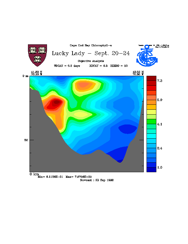
We compared our model simulations with direct measurements. Model estimated chlorophyll-a transect from south to north along the Cape Cod and Mass Bay and corresponding fluorometer measurement during Sept. 20-24 are given in Figure 5 and Figure 6, respectively. It should be noted that fluorometer measurements are not calibrated and in relative units and the northern portion of the basin was not sampled in this particular cruise. So, we can only compares scales and relative distributions. If we compare model forecast at September 23 (Figure 5b) with observations; depth of the chlorophyll maxima and scales of the patchiness correlates well expect northern part of the basin. As it is noted earlier, there is no data in the northern part of the basin and OA extension was generating data at this part of the basin. In the southern part we predicted scales of the chlorophyll maxima exactly.
Horizontal scales of the patchiness are given in Figure 7 and Figure 8 for the same dates as above.
The data will be acquired, then the data will be processed for quality control. Important issues remaining include a proper interpretation of the fluorescence, sound backscattering signals, and cross validation. How to use the remotely sensed color once the pre-processing problems are overcome at CMAST.
After assessing our final data holdings (coverage, type, errors), we will proceed to review and extend our data driven simulations. Re-examination of model parameters will be done as needed. Data-driven simulation will include assimilation of the diverse data streams. Presently we understand how to prepare biogeochemical fields for assimilation and made preliminary data assimilation experiments with data.
Data driven simulations using a six compartment nitrogen cycle model has been calibrated for the region and for the summer regime in the Mass Bay region. Initial biogeochemical fields were constructed based upon historical data. The known phenomenology during this period is well represented in the simulations.
Biogeochemical model forecasting during MBST-99 requires initialization of the model with winter-spring data driven by previous years forcing. For this purpose, the winter-spring data from MWRA should be obtained. This data set should include February, March, April and May and parameter required are Temperature, salinity, NO3, NH4, Chlorophyll, Phytoplankton, Zooplankton, POC, PON, TOC, DOC, DON, Light, Fluorescence. Far field cruises of the MWRA mostly required.
MWRA data set will be used for both initialization of the model and testing the assimilation methodology. Model will be initialized from winter data and will be run through the spring, assimilating March, April and May data set. This exercise is essential to become ready before real-time forecasting.
GOM domain should be studied and model should be prepared for this domain. Nesting of the biological model is not ready yet and to solve the problems at the boundaries there is a strong need for nesting of the physics and probably the biology.
Riverine inputs and atmospheric fluxes to the region should be identified.
Tidal circulation and mixing should be included. The physical model is ready but not yet tested.
Before any Lucky Lady MBST-99 initialization survey, the fluorometer should be calibrated. This can be done by collecting chlorophyll samples. There is a need to make profile measurements to clarify vertical distribution from fluorometer measurements.
MWRA winter zooplankton data should be examined and most dominant taxa should be identified. This will help to convert TAPS measurements to model units.
There is a need to collect chemical data (NO3, NH4 (less priority), and TSS. TSS data will be useful in interpreting TAPS data.
The authors thank: the Mass. Water Resources Authority (MWRA) and Dr. Mike Mickelson for historical data and assistance in processing measurements; Prof. Tommy Dickey, Dr. Barry Bjork and Dr. Dave Sigurdson of UCSB for data acquisition; Dr. D.V. Holliday of Marconi Aerospace for use of the TAPS profiling system; and Dr. Avijit Gangopadhyay and Dr. Brian Howe of CMAST for logistical arrangements for the R/V Lucky Lady and data analysis. This research is supported by AFMIS (U/NASA NAG13-48), LOOPS (ONR N00014-97-1-1018) and ONR through N00014-97-1-0239.
Figure 1. Conceptional design of the biochemical model.
Figure 2. Model domain and MWRA sampling stations.
Figure 3. Velocities overlapped on to Chlorophyll-a distribution at 10 for 4 different case in the Mass Bay. a)Calm wind condition. b) Upwelling in the Cape Cod Bay caused by northeasterly winds, c) Transportation of the Boston Harbor waters to the south by southward flow, d) Effect of the westerly winds causing transport Boston Harbor waters to northern boundary of the Mass Bay and driving upwelling along the northern coast.
Figure 4. Transects of the Temperature, Nitrate, Chlorophyll and Zooplankton from Cape Cod Bay to the northern coastline of the Mass Bay for 6, 10, 14, 20, 30, 40 days forecast.
Figure 5. Model estimated Chlorophyll-a distributions from Cape Cod Bay to the northern coastline of the Mass Bay between Sep. 22 and Sep. 25, 1998.
Figure 6. Measured chlorophyll fluorescence from Cape Cod Bay to the northern coastline during September 20-24. There are no measurements in the northern half of the basin and this portion of the transect is extended for presentation.
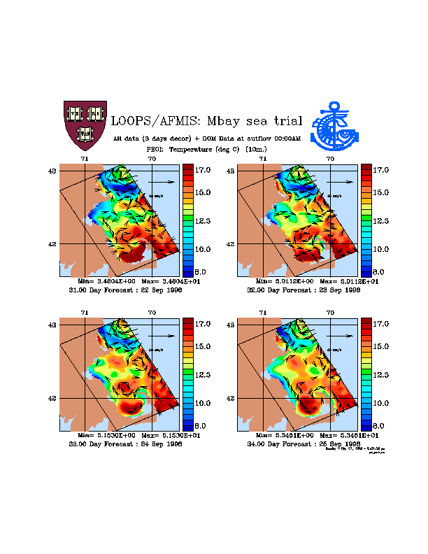
Figure 7. Model estimated temperature distributions at 10m. during Sep. 22 through Sep. 25, 1998.
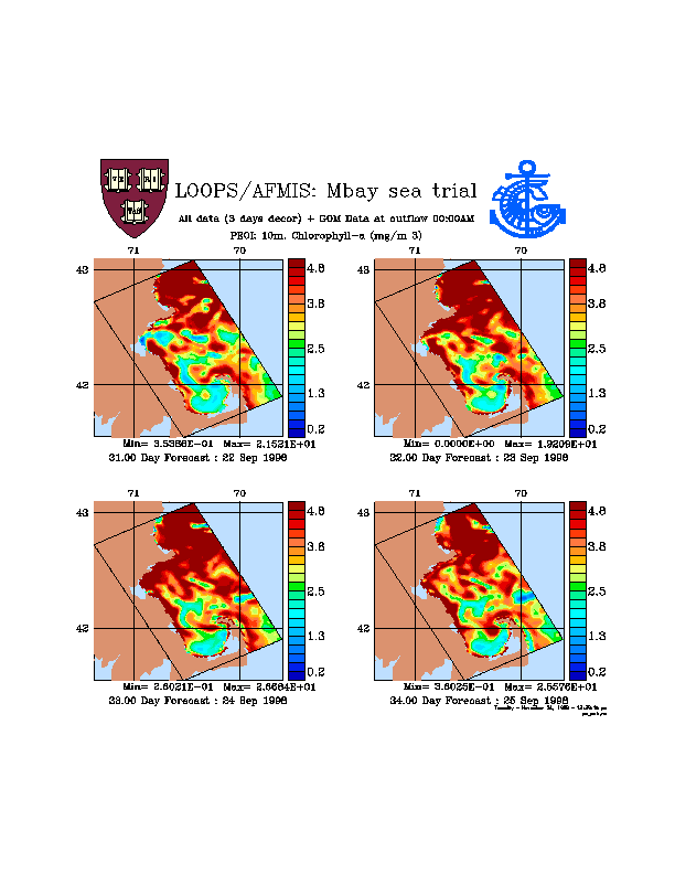
Figure 8. Model estimated chlorophyll-a distributions at 10m. during Sep. 22 through Sep. 25, 1998.