Accurate estimation of four dimensional interdisciplinary fields in the ocean is essential for modern ocean science and technology. For many applications the continuous time evolution of three dimensional synoptic realizations over a large regional domain with (sub) mesoscale resolution are required for physical, biological, chemical, acoustical and optical state variables, e.g., velocity, temperature, biomass, nutrients, sound speed, and radiation fields. There are many couplings and interactions among these fields which provide both challenges and opportunities for the use of interdisciplinary techniques. Field estimation in the ocean is complex and data sets are generally sparse compared to requirements. This is for the most part due to the presence of a large range of interactive space and time scales associated with the wide variety of oceanic phenomena. The coastal ocean is particularly challenging because of multiple forcings, complex geometries, and boundary interactions.
Sustained accurate and efficient oceanic field estimates are now feasible because of the advent of ocean observing and prediction systems. Such systems produce nowcasts, forecasts and data-driven simulations by melding dynamics and observations via the assimilation of measurements into numerical models. Assimilation provides dynamical adjustment and dynamical interpolation. Error models play a critical role and the melded estimates should agree with the observations within observational errors and satisfy the dynamics within dynamical model error bounds. Ocean prediction systems provide mechanisms for important feedbacks including adaptive sampling for the observational component and improved dynamics for the model component.
An efficient and generally applicable coastal ocean prediction system must take into account the wide variety of coastal phenomena (currents, waves, tides, etc.) and forcings (buoyancy, wind, external) which occur over the multiplicity of time and space scales. The observational network will generally consist of a mix of platforms and sensors with real time telemetry deployed in nested domains of increasing resolutions. The set of coupled interdisciplinary models for assimilating the data will have compatible two-way nested computational domains. Prediction systems should accelerate scientific research progress in the multiscale intermittent ocean and important practical application areas include management of the multiuse coastal zone and naval and marine operations.
The development of specific regional predictive capabilities must take into account regional phenomena and the intended applications of the system. Accuracies must be determined and validation criteria established. It is useful to distinguish three phases [Robinson et al., 1996a]. In the first descriptive or exploratory phase dominant scales, processes and interactions are identified and a model is set up and validated as adequate to encompass the relevant dynamics. In the second, or dynamical phase, a definitive knowledge of the circulation structures and interactions must be achieved and the specific dynamical processes that govern the evolution of synoptic features and events established. During this phase the regional predictive system is calibrated. In the third, or predictive phase real time forecast experiments with dense high quality data sets must be carried out to verify the system. The final step is the design and verification of an efficient regional forecast system with minimal observational resources for the desired accuracies and applications.
In the remainder of this chapter we introduce the Harvard Ocean Prediction System (HOPS) and then illustrate its recent application to three diverse coastal and shelf regions with various forcings and phenomena: i) the Middle Atlantic Bight shelf/slope front driven by buoyancy effects and dominated by internal dynamical instabilities; ii) Haro Straits tidal fronts driven by the interaction of intense tides and an estuarine circulation in the presence of tidal and topographically induced mixing, and iii) the variability of the Atlantic Ionian Stream system in the Strait of Sicily and the western Ionian Sea driven by the general circulation, internal dynamics and regional atmospheric fluxes. The first example involves data-driven simulations carried out for fundamental dynamical process research. The second example was carried out as part of a proof of concept demonstration and involved providing real time frontal predictions as input to adaptive sampling mission design for deployments of autonomous underwater vehicles. The third example involved six weeks of real time nowcasting and forecasting, initiated on shipboard, which provided environmental guidance for NATO naval operations and maneuvers.
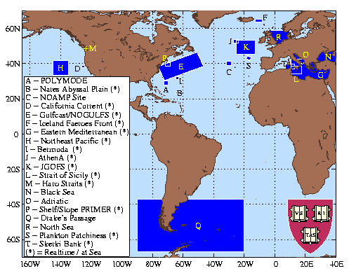
HOPS is a flexible, portable and generic system for nowcasting, forecasting and simulations. In addition to its use in fundamental process studies, HOPS can be rapidly deployed to any region of the world ocean, including the coastal and deep oceans and across the shelfbreak with open, partially open or closed boundaries. Real time and at sea forecasts have been carried out for more than a decade in fifteen sites in the Atlantic and Pacific Oceans and the Mediterranean Sea (vid Fig. 1). Recent reviews by Robinson [1996a], Robinson et al. [1996b] and Lozano et al. [1996] provide a comprehensive presentation of the system and overview of its applications including coupled physical-acoustical [Robinson and Lee, 1994; Robinson and Lozano, 1998] and physical-biological [McGillicuddy et al., 1995; McGillicuddy and Robinson, 1997; Anderson et al., 1998; Anderson and Robinson, 1998] studies. A rigorous quantitative verification has been achieved for the Iceland-Faeroe Islands frontal system [Robinson et al., 1996c]. Here we will only briefly highlight a few points and new developments.
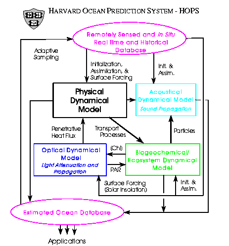
The overall system schematic is shown on Fig. 2. The heart of the system for most coastal applications is a primitive equation physical dynamical model which has been specially structured for accurate and efficient calculations over steep topography [Lozano, et al., 1994; Haley, 1996]. Vertical coordinate options include sigma, hybrid and multiple sigma coordinate transformations which are calibrated for specific applications via sensitivity analyses to both vertical and horizontal resolutions [Sloan, 1996, Chapter II]. Horizontal coordinate options include multiple two-way nests [Sloan, ibid.]. A variety of physical, biological and acoustical, in situ and remotely sensed, data types have been assimilated in a variety of applications. The data analysis and management modules of HOPS represent a major resource of the Harvard system. HOPS methodology involves the construction of a best possible initial synoptic realization as a starting point for the assimilation of new synoptic data. There is an emphasis on the treatment of data prior to assimilation in order to maximize the impact of new data in the light of prior data. Structured data models [Lozano et al., 1996] are utilized for this purpose, e.g., feature models or typical synoptic structures [Gangopadhyay et al., 1997; Robinson and Gangopadhyay, 1997; Gangopadhyay and Robinson, 1997] and empirical orthogonal functions (EOFs) in one to three dimensions. Recent developments include: i) the use of temperature and salinity based, rather than velocity based, feature models which are more suitable over steep topography; ii) the addition of a dynamically balanced vertical velocity to the feature models for initialization and assimilations which will couple physics and biology; and, iii) the optical dynamical component (Fig. 2). For the construction of best possible synoptic realizations multiple data streams, including structured data models and seasonally adjusted historical synoptic realizations, are melded. The modularity of HOPS facilitates the selection of a subset of modules to form an efficient configuration for specific applications and also facilitates the addition of new or substitute modules.
A robust (suboptimal) optimal interpolation (OI) data assimilation scheme with weights set by simple engineering-type assumptions has been used in HOPS for several years [Lozano et al., 1996]. OI, well understood by meteorologists, was adopted in order to focus research resources on the assimilation of real ocean data sets rapidly into the ocean dynamical models for a first round of impact studies. A second quasioptimal assimilation scheme option, Error Subspace Statistical Estimation (ESSE) [Lermusiaux, 1997; Lermusiaux and Robinson, 1998], has been developed and recently added to the system. A rational approach was used to identify an efficient statistical estimation scheme feasible for use in real time with real oceanic data sets. The ESSE goal is to determine the nonlinear evolution of the oceanic state by minimizing the most energetic errors under the constraints of the dynamical and measurement models and both of their uncertainties. Error propagation is estimated via an ensemble forecast using the full nonlinear model. The evolving error subspace is characterized by singular error vectors and values, i.e., time evolving three dimensional error EOFs. Melding weights for assimilation are determined using a minimum error variance criterion. Importantly, melding occurs in the error subspace and is thus much less costly than a classical analysis with the full error covariances. The error subspace is updated at the melding step by combining the forecast principal errors, i.e., errors arising from the dynamical model and the loss of predictability, with the error covariances of the measurements. An example of ESSE assimilation is presented in Section 3.3.
The frontal boundary between colder, fresher shelf waters and warmer, saltier slope waters off the northeast coast of the United States, although partially density compensated, supports a frontal jet which exhibits vigorous submesoscale meandering and eddying variabilities. The dynamics of this frontal system, which is not yet well understood, is of interest not only in its own right, but also because the associated variabilities give rise to shelf-slope exchange processes for heat, nutrients, etc. The determination of the qualitative and quantitative characteristics of these exchange processes are important topics in research on deep sea/coastal ocean interactions. Dynamical studies via both idealized process studies and data driven simulations have been carried out [Sloan, 1996] and nowcasting, forecasting and simulations of coupled physical and acoustical fields is currently in progress [Robinson et al., 1997a].
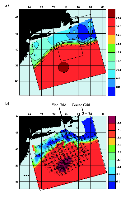
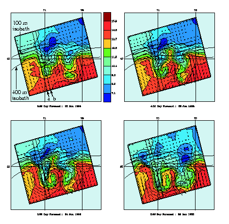
For initialization of the shelf-slope front a temperature and salinity based feature model was constructed which, under appropriate parameters, develops within a few days realistic variabilities. Shelf-slope interactions have been studied both in the absence and presence of warm core rings of Gulf Stream origin. Data sets assimilated were from the extensive synoptic hydrographic surveys with nominal 25km sampling of the MARMAP project [Mountain and Holzworth, 1989] and the very high resolution hydrographic data taken from the RV Bear in 1958 in a one degree square centered at 39.5� N latitude and 70.5� W longitude. Fig. 3a shows an initialization field consisting of a feature model shelf break front and a feature model ring embedded into shelf MARMAP climatology and a uniformly stratified slope. MARMAP synoptic data from May, 1984 is assimilated into the initialization of the 30-day long simulation. A two-way nested inner grid of 3 km resolution is embedded in the larger regional domain of 9 km resolution. The simulation on day 24 (Fig. 3b) illustrates an interesting type of far field ring frontal interaction. Two long filaments of shelf water are being drawn out and an isolated shelf water eddy is present. Note that the nest successfully copes with the presence of a partial ring in the fine domain. A four day time series from a similar simulation with no ring but with RV Bear data assimilated is shown on Fig. 4 for the inner domain. Assimilation took place during days 3 and 6. Both shelf and slope waters intrude across the shelf-break and two way exchanges occur. Results of these studies indicate early growth of at least two types of unstable waves followed by spectral saturation at many scales, nonlinear wave steepening and nonlinear transfer to larger scales, events, vortices, and hammerheads. The front has been observed to reestablish itself from a turbulent variability field over steep topography.
|
|
|
|
|
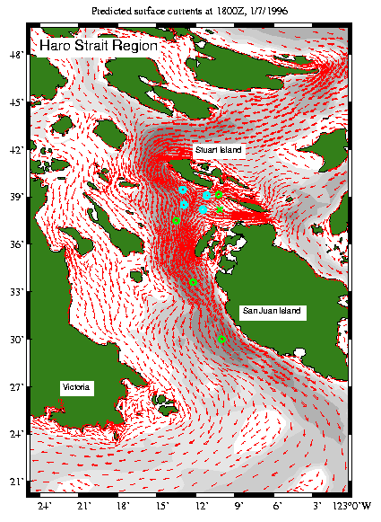
Haro Straits lie to the east of Vancouver Island between the Straits of Georgia and Juan de Fuca (Fig. 5), to the north and south, respectively, of Stuart Island. These straits constitute a large estuarine system in which salty water of North Pacific origin flows northward at depth and is mixed with fresher water primarily of riverine origin flowing above it seaward and southward. Haro Straits is believed to be the region where most of the mixing takes place, although the relative importance of possible mixing processes and locations has not been established [Farmer et al., 1995]. The estuarine circulation is dynamically coupled to an energetic tidal flow with speeds in the region as high as 2 m/s [Foreman et al., 1995]. Driven by several tidal forcing constituents, the tidal circulation varies from day to day as well as on longer time scales, with maximum tides occurring in June and July. The complex topography and island geometry (Fig. 5) causes the flow to be accelerated through passages between islands and over sills which provides a mixing mechanism. A variety of tidal fronts occur in the region. In particular a tidal front with a generally north-south axis is often observed to occur to the south of Stuart Island.
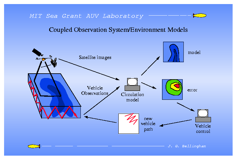
In the summer of 1996 the Harvard group participated in a coupled physical and acoustical study of the Haro Straits tidal frontal phenomena in collaboration with scientists from the Institute of Ocean Science (Sidney), Massachusetts Institute of Technology, and the Woods Hole Oceanographic Institution [Schmidt et al., 1996; 1997; Nadis, 1997]. The project objectives were oriented both towards: i) the investigation of basic scientific dynamical processes; and ii) the development of ocean predictive system methodology with adaptive sampling. Platforms included ships, aircraft, moorings, floats and autonomous underwater vehicles (AUVs). The HOPS participation focused on the ebb tidal front south of Stuart Island. Real time HOPS predictions with data assimilation carried out from 24 June to 3 July 1996 were supplied to the MIT AUV group, who took them to sea on operational work stations aboard the vehicle tender vessel. The forecasts were used to adapt the AUV mission tracks for efficient sampling of the front and for verification missions. HOPS functioned as the circulation model central to the AUV Laboratory's general system schematic shown on Fig. 6. The decision to participate with HOPS in June 1996 was taken only in April 1996 and thus this exercise required a rapid setup of a forecast system for an unfamiliar region of highly complex and poorly understood phenomena and rugged geometry and topography. The main objective was to demonstrate the concept of real time predictions for adaptive sampling, with data assimilation and feedbacks between the model and observational components of the overall observational and predictive system.
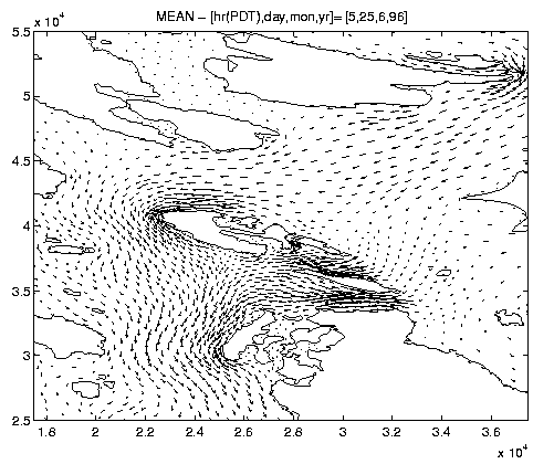
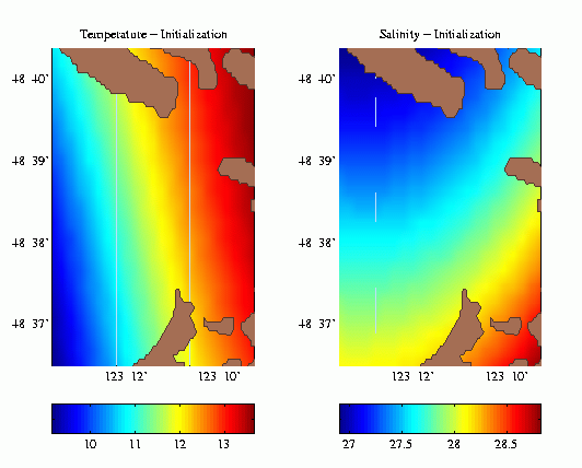
The front south of Stuart is observed to form during ebb tide and to disappear flood. During ebb there is a flow from the north of the island around both the eastern and western sides of the island, which converges to the south of the island and continues to flow southward, e.g., (Fig. 7). At slack the flow reverses. A study of particle trajectories associated with the tidal circulation was carried out based on the IOS tidal flow model [Foreman et al., 1995]. It was found that water parcels on either side of the ebb front had originated in close proximity to each other to the north of Stuart. Approximately two tidal cycles were required for the water to be transported permanently from the north of the island to the south of the island. There are two major channels to the west and south of Stuart (Fig. 5) (New and Speiden Channels). The hypothesis was introduced that mixing in the flow through these channels was much more intense than in the flow through Haro Straits to the west of Stuart, which together with the shear deformation and convergence in the tidal flow caused the front. A mixing model quadratic in the flow and inversely proportional to the depth was used. Because of the short time available a simple prototype version of HOPS was set up. Temperature and salinity fields were mixed and advected by the IOS tidal velocities in the upper layer of a conceptual two layer model. The primitive equation with combined tidal, wind and buoyancy driving and a more sophisticated mixing model is a natural extension. For the prototype model utilized, Fig. 8a shows a salinity initialization based on NODC historical data, 24 hours prior to the maximum ebb tide situation shown on Fig. 8b, which illustrates the frontogenetical mechanism.
|
|
|
|
|
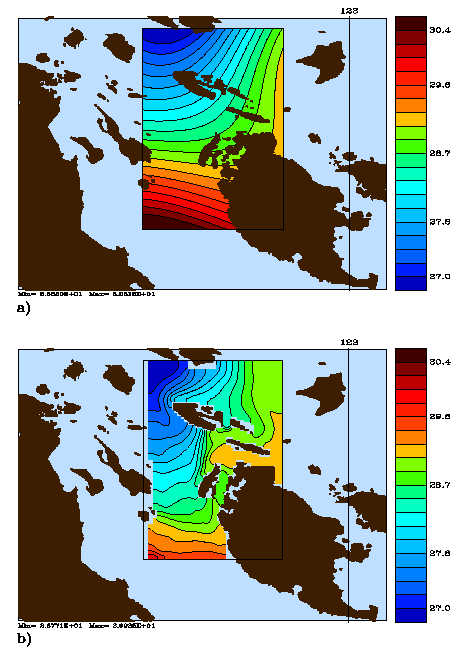
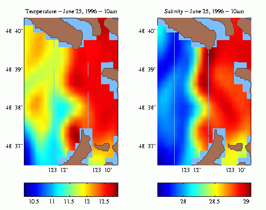
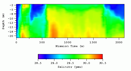
The real time operational forecasts assimilated CTD data from both the prior day's AUV missions and a daily survey from a charter vessel. The charter vessel sampling was subjectively designed each day by the Harvard group based on the HOPS forecast. The daily AUV mission and CTD surveys were carried out nominally from 6 a.m. to 12 noon. Thus the daily forecasts were of 36 hours duration in order to allow the assimilation of the prior day's data and to extend into the forecast day's mission time. For each forecast, temperature and salinity were initialized by climatology. A systematic verification study is in progress. A successful example is presented on Fig. 9 for 25 June 1996. The initial temperature and salinity are shown on Fig. 9a,b and the predicted fronts during ebb and at about midpoint of the morning AUV operation are shown on Fig. 9c,d. Guided by this prediction CTD carried by an AUV accomplished a successful and detailed sampling of the front which also provided an excellent verification of the HOPS forecast. The AUV salinity section on Fig. 9e was obtained by the vehicle yo-yoing between the surface and 20 m along a 3 km track normal to the front at about 48� 39' N; the vehicle reversed direction half-way through the mission and thus crossed the front twice.
|
|
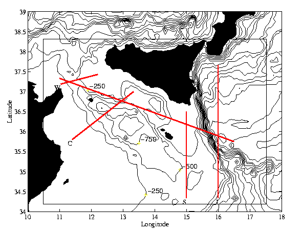
South of the island of Sicily and north of the African coast, a narrow strait (Fig. 10) connects the western and eastern basins of the Mediterranean Sea. In the west there is a shallow ( � 250m) sill and to the east a steep shelfbreak, past which the bottom plunges from only a few hundred meters to the depth of two to three thousand meters. The shelfbreak fans out to the south and the shelf-slope region north of Libya is broad and gentle. The flow in the region is driven both by Mediterranean general circulation features and local atmospheric fluxes. In the upper ocean, relatively fresh water of Atlantic origin flows eastward in a topographically controlled jet, the Atlantic Ionian Stream (AIS) (Fig. 11), which, after flowing northward along the narrow shelfbreak, separates into the western Ionian Sea. Wind-driving can maintain a coastal current off Sicily and can induce biologically important upwelling events. In 1994, the Harvard group undertook the development of a regional forecast system for this region in collaboration with SACLANT Undersea Research Centre scientists, led initially by Dr. Alex Warn-Varnas and subsequently by Dr. Jurgen Sellschopp. The region was chosen as a test bed for developing HOPS coastal capabilities because of its challenging geometry and topography and the variety of interactive processes and driving mechanisms. An exploratory cruise in November, 1994 (AIS 94) led to the design of a definitive survey for the regional circulation features, which was completed in October, 1995 (AIS 95) [Robinson et al., 1998]. From mid-August to early October in 1996, NATO navies carried out in this region an exercise in rapid environmental assessment called Rapid Response 96 (RR96) during which HOPS was used for real time operational nowcasts and forecasts [Sellschopp and Robinson, 1997].
|
|
|
|
|
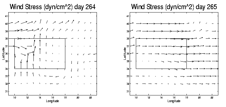
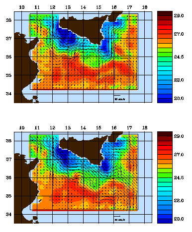
HOPS was initialized and run at sea aboard the NRV Alliance from 12 to 22 August; subsequent forecasts were carried out at the SACLANT Centre. The nowcast and forecast maps shown on Figure 11 are taken directly from the RR96 web site, where they were made readily accessible to interested participants. Standard sound speed sections were prepared as indicated on Figure 10. At the start of the exercise, a first guess synoptic realization was prepared by warming the October 1995 realization to August conditions by artificial surface heating of the fields while under the constraint of primitive equation dynamics. As it was acquired by the ship, hydrographic data was assimilated into this circulation. Sufficient data was avilable by 24 August for a new initialization using only contemporary data. Forecasts continued into early October. Based upon subjective interpretation of the HOPS forecasts, adaptive sampling patterns were designed for the latter part of the ship's cruise and for the two to three AXBT flights per week throughout the duration of the exercise. The U.S. Navy's Fleet Numerical Meteorological and Oceanographic Center products were used to prepare atmospheric momentum, heat and fresh water fluxes at Harvard, which were then relayed to the forecast center.
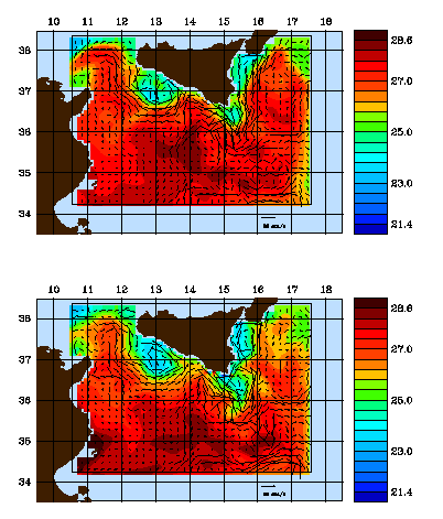
Figure 11 illustrates the nature of the mesoscale variabilities occurring in the main thermocline due to internal dynamics. The axis of the AIS is a thermal front at about 26�C. Notable features are the Adventure Bank Vortex (ABV) centered at � (37�N, 13�E), the Maltese Channel Crest (MCC) (37�N, 14�E) and the Ionian Shelfbreak Vortex (ISV) (36.5�N, 15.25�E). Comparing Figs. 11a and 11b, the extent, shape and configuration of these features are seen to shift and vary over tens of kilometers on a time scale of three to four days. Additional near surface variabilities occur due to local atmospheric forcing, as shown on Figure 12. A shift of the wind from southerly and weak (12a) to westerly (12b) is accompanied by a significant shifting and strengthening of the surface currents (12c,d).
|
|
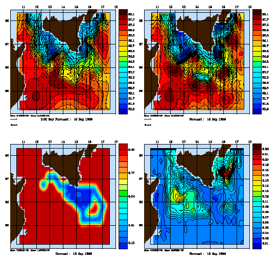
The ESSE methodology described at the end of Section 2 was used in real time for the first time to produce a research-operational forecast of fields and errors as a demonstration of concept and feasibility. Results are presented in Figure 13 for a three day forecast before assimilation (13a) and after (13b). The pattern of the expected error of the objectively analyzed AXBT data (13c) indicates a flight designed first to tie down the shape of the ISV and then to accurately map a local region of operational interest. The forecast error map after assimilation (13d) indicates error maxima which need to be sampled in future flights. Utilizing three SUN Ultra Sparc 2 CPUs and one Sparc 20 (4 CPU) workstations, the three day forecast took one day of wall clock time. Follow-up parameter sensitivity studies and considerations of improved networking of parallel computations [Lermusiaux, 1997] indicate that elapsed time for producing real time forecasts could be halved.
The time evolution of the regional circulation is driven by internal dynamical processes, inflow and outflow boundary conditions and surface atmospheric fluxes. Knowledge of internal dynamical processes and boundary conditions is affected byt he calibration and tuning of the ocean dynamical model and the quality, quantity and distribution of oceanic data. The knowledge of surface forcing is affected by the type, accuracy and quantity of atmospheric fluxes and the accuracy of the atmospheric weather forecasts. In addition, both the atmosphere and the ocean have predictability limits of a few days and a week or two, respectively, due to internal nonlinear dynamics. A quick-look verification comparison (Robinson at al., 1998) of HOPS RR96 forecasts with nowcasts and AVHRR composite SSTs indicated that variability indices for the location and shape of the ABV, MCC and ISV were predicted at a success rate of approximately 75%. Thus, RR96 indicates that a usefully accurate forecast capability for a few days has been achieved for the region.
The melding of data and dynamics via assimilation of observations into coastal ocean observing and prediction systems provides a powerful new methodology of field estimation. Such systems must be anticipated to significantly accelerate progress in coastal ocean science and to enhance capabilities for efficient and comprehensive coastal zone management and operations.
The Harvard Ocean Prediction System (HOPS) is a flexible, portable and generic system for nowcasting, forecasting and simulations which can be utilized in any region of the world ocean: coastal and deep ocean and across the shelf break. The physical dynamical model is primitive equation based and data assimilation schemes include optimal interpolation and a novel quasi-optimal algorithm (error subspace statistical estimation) which efficiently forecasts both errors and fields. A variety of physical, biological and acoustical, in situ and remotely sensed, data types have been assimilated in a variety of applications and regions. HOPS has recently been successfully applied to three diverse coast and shelf regions: the Middle Atlantic Bight shelf/slope front, Haro Straits tidal front, and the Atlantic Ionian Stream system in the Strait of Sicily and the western Ionian Sea. Qualitative and quantitative comparisons indicate that usefully accurate real time operational forecast capabilities have been achieved.
Anderson, L.A., A.R. Robinson and C.J. Lozano, Physical and biological modeling in the Gulf Stream region: I. Data assimilation methodology, Deep-Sea Res., submitted, 1998.
Anderson, L.A., and A.R. Robinson, Physical and biological modeling in the Gulf Stream region: II. Physical and biological processes, Deep-Sea Res., submitted, 1998.
Farmer, D.M., E.A. D'Asaro, M.V. Trevorrow and G.Y. Dairiki, Three dimensional structure in a tidal convergence front, Cont. Shelf Res., 1649-1673, 1995.
Foreman, M.G.H, R.A. Walters, R.F. Henry, C.P. Keller and A.G. Dolling, A tidal model for eastern Juan de Fuca Strait and the southern Strait of Georgia, J. Geophys. Res., 100(C1), 721-740, 1995.
Gangopadhyay, A., A.R. Robinson, and H.G. Arango, Circulation and Dynamics of the Western North Atlantic, I: Multi-Scale Feature Models, Journal of Atmospheric and Oceanic Technology, 14:1314-1332, 1997.
Gangopadhyay, A. and A.R. Robinson, Circulation and Dynamics of the Western North Atlantic, III: Forecasting the Meanders and Rings Journal of Atmospheric and Oceanic Technology, 14:1352-1365, 1997.
Haley, P.J., Jr., GRIDS, Harvard Open Ocean Model Reports, 54, 13pp., 1996.
Lermusiaux, P.F.J., Error Subspace Data Assimilation Methods for Ocean Field Estimation: Theory, Validation and Applications, Ph.D. Thesis, Harvard University, Cambridge, Massachusetts, 1997.
Lermusiaux, P.F.J. and A.R. Robinson, Data assimilation via Error Subspace Statistical Estimation, Part I: Theory and Schemes, Month. Weather Rev., in press, 1998.
Lozano, C.J., P.J. Haley, Jr., H.G. Arango, N.Q. Sloan and A.R. Robinson, Harvard coastal/deep water primitive equation model, Harvard Open Ocean Model Reports, 52, 15pp., 1994.
Lozano, C.J., A.R. Robinson, H.G. Arango, A. Gangopadhyay, N.Q. Sloan, P.J. Haley, and W.G. Leslie, An Interdisciplinary Ocean Prediction System: Assimilation Strategies and Structured Data Models, Modern Approaches to Data Assimilation in Ocean Modelling (P. Malanotte-Rizzoli, editor), Elsevier Oceanography Series, Elsevier Science, The Netherlands. 413-452, 1996.
McGillicuddy, D.J., A.R. Robinson, and J.J. McCarthy, Coupled Physical and Biological Modeling of the Spring Bloom in the North Atlantic, II: Three-Dimensional Bloom and Post-Bloom Effects, Deep-Sea Research I, 42(8), 1359-1398, 1995.
McGillicuddy, D.J. and A.R. Robinson, Eddy-induced nutrient supply and new production in the Sargasso Sea, Deep-Sea Res., 44(8):1427-1450, 1997.
Mountain, D.G. and T.J. Holzworth, Surface and Bottom Temperature Distribution for the Northeast Continental Shelf, Technical report, National Oceanographic and Atmospheric Administration, 1989.
Nadis, S., Real-Time Oceanography Adapts to Sea Changes, Science, 275, 1881-1882, 1997.
Robinson, A.R. and D. Lee, Ocean Variability, Acoustic Propagation and Coupled Models, Oceanography and Acoustics: Prediction and Propagation Models (A.R. Robinson and D. Lee, editors), American Inst. of Physics, New York, 1-6, 1994
Robinson, A.R, Physical Processes, Field Estimation and Interdisciplinary Ocean Modeling, Earth-Science Reviews 40, 3-54, 1996a.
Robinson, A.R., H.G. Arango, A. Warn-Varnas, W.G. Leslie, A.J. Miller, P.J. Haley, and C.J. Lozano, Real-Time Regional Forecasting, Modern Approaches to Data Assimilation in Ocean Modelling (P. Malanotte-Rizzoli, editor), Elsevier Oceanography Series, Elsevier Science, The Netherlands. 377-412, 1996b.
Robinson, A.R., H.G. Arango, A.J. Miller, A. Warn-Varnas, P.-M. Poulain, and W.G. Leslie, Real-Time Operational Forecasting on Shipboard of the Iceland-Faeroe Frontal Variability, Bulletin of the American Meteorological Society 72(2), 243-259, 1996c.
Robinson, A.R. and A. Gangopadhyay, Circulation and Dynamics of the Western North Atlantic, II: Dynamics of Meanders and Rings. Journal of Atmospheric and Oceanic Technology. 14:1333-1351, 1997.
Robinson, A.R., C.J. Lozano, W.G. Leslie, L.A. Anderson, P.J. Haley, Jr. and J.A. Dusenberry, Scientific objectives and plans for real-time simulation experiment and operations: Plankton Patchiness Studies by Ship and Satellite, Harvard Open Ocean Model Reports, 55, 37pp., 1997a.
Robinson, A.R. and C.J. Lozano, Progress in Ocean Science and Ocean Acoustics, Keynote Address, Theoretical and Computational Acoustics '97 (Yu-Chiung Teng et al.), World Scientific Publishing Co., Singapore, 1998.
Robinson, A.R., J. Sellschopp, A. Warn-Varnas, W.G. Leslie, P.J. Haley, Jr., P.F.J. Lermusiaux and L.A. Anderson, The Atlantic Ionian Stream, Journal of Marine Systems, In press, 1998.
Schmidt, H., J.G. Bellingham, M. Johnson, D. Herold, D.M. Farmer and R. Pawlowicz, Real-time frontal mapping with AUVs in a coastal environment, Proceedings, Oceans '96, Ft. Lauderdale, FL, 1996
Schmidt, H., J.G. Bellingham and P. Elisseeff, Acoustically Focused Oceanographic Sampling in Coastal Environments, Proc. Int. Conf. Rapid Environmental Assessment, Lerici, Italy, Mar. 10-14, 1997.
Sellschopp, J. and A.R. Robinson, Definition and Forecasting of Ocean Conditions During Rapid Response, Proc. Int. Conf. Rapid Environmental Assessment, Lerici, Italy, Mar. 10-14, 1997.
Sloan, N.Q., Dynamics of a Shelf-Slope Front: Process Studies and Data-Driven Simulations in the Middle Atlantic Bight, Ph.D. Thesis, Harvard University, Cambridge, Massachusetts, 1996.
Translation by Wayne G. Leslie On 18 February 2000, 09:53.